Motivation
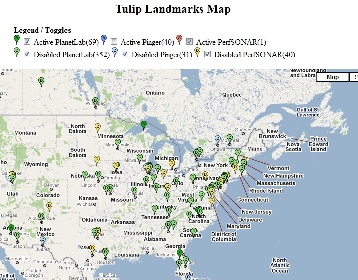
We have three different sets of landmarks deployed all over the world, depending on performance some of them may be active while other are disabled. There are two maps, one for each set of landmarks. This enables us to see them based on their location. Map for active landmarks can be seen at http://www.slac.stanford.edu/comp/net/wan-mon/viper/tulipmap.html while the map for disables landmarks can be seen at http://www.slac.stanford.edu/comp/net/wan-mon/viper/tulipmap_d.html
Types of Landmarks
- PlanetLab Landmark sites
- PingER Landmark sites
- PerfSONAR Landmark sites
Methodology
Two XML files are used for getting node information. These XML files are created from a perl script at /afs/slac.stanford.edu/package/pinger/tulip/generatexmlnodes.pl. The html file (tulipmap.htm) is placed at /afs/slac.stanford.edu/www/comp/net/wan-mon/viper
XML Pattern for a node
<item>
<title>"United Kingdom"</title>
<link>87.84.153.115</link>
<lat>54.988</lat>
<lon>-1.6</lon>
<host>csplanet02.cs-ncl.net</host><region>Europe</region>
<type>PlanetLab</type>
<subject>dPl</subject>
</item>
Distinguishing subject tags
<subject>aPl</subject> // Active Planet Lab
<subject>dPl</subject> // Disabled Planet Lab
<subject>aPingER</subject> // Active PingER
<subject>dPingER</subject> // Disabled PingER
<subject>aPerf</subject> // Active PerfSONAR
<subject>dPerf</subject> // Disabled PerfSONAR
