Introduction
We want to compare the various methods of geolocation using ping RTT measurements to estimate the distance between landmarks and targets. The landmarks are at known lat/longs and the min RTT from the three (Tri-Lateration) or more closest landmarks to the target are used. From each min RTTs the distance to the target is estimated as distance (km) = alpha * minRTT(ms) * 100 (km/ms). In these tests we use each of the other landmarks (at known locations) one at a time as targets (si we know the location of the targets also). Comparing the actual location of the target and the estimated location we were able to calculate the error as the distance between these two values. There is a spreadsheet with more details.
Constraint Based Geolocation (CBG) using Tri-lateration vs Tri-Lateration with no constraints
We started with 174 targets. Of these CBG modified to only use 3 landmarks returned 15 with no useful result. Tri-Lateration was only able to provide results for 76 of the targets. The number of targets that were found with both CBG with tri-lateration and tri-lateration with no constraints (henceforth referred to simply as Tri-lateration) was 73.
For these 73 targets CBG using tri-lateration gave a lower error 63/73 times and Tri-lateration 10/74 times. If we also remove the results where the errors were < 1km (i.e. the target's geolocation was being estimated by nearby landmarks on the same site) then the number of useful results dropped to 41 with CBG using Tri-lateration having a lower error 32/41 times. The distributions (excluding CBG with tri-lateration results where the error was < 1km) are compared in Figure 1 below.
Figure 1: Histograms of the frequency and cumulative distributions for CBG with tri-lateration, Trilateration and Apollonius algorithms for estimating the geolocation |
|---|
|
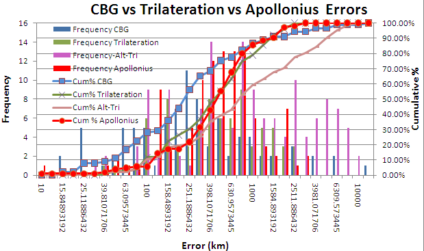
It is seen that Trilateration with no constraints has a median value of ~ 412km, while CBG with Tri-lateration is closer to 250km.
Comparison with the Apollonius Geolocation Algorithm
We also evaluated the performance of the Apollonius geolocation algorithm that uses tangential circles rather than the intersecting circles of tri-lateration. In this case we had successes with 105 targets. The frequency and cumulative distributions are seen in Figure 1. It is seen that Apollonius performs similarly to Tri-lateration with a median error of about 449ms.
Comparison of CBG with Multi-lateration and Tri-lateration
We then compared our modified CBG using tri-lateration with CBG using Multi-lateration. The distributions are shown below, and more details are in the spreadsheet .
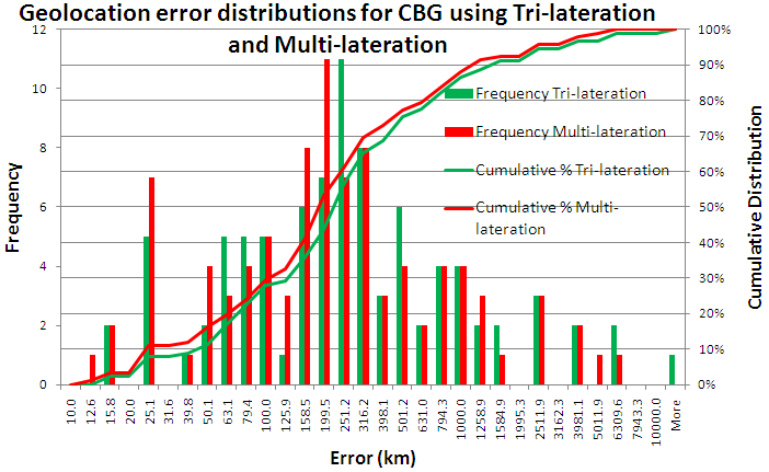
It is seen that the two dsitributions are very similar with multi-lateration having a smaller median error. It also has a higher success rate (see the table below).
Metric |
CBG with Multi-lateration |
CBG with tri-lateration |
Trilateration |
Apollonius |
|---|---|---|---|---|
% success rate |
92% |
91% |
44% |
63% |
Median |
190km |
250km |
413km |
449km |
Files
Created by Zafar Gilani, sent by email 6/14/2010. It compares trilateration (3 landmarks) with mulitlateration (3 to 5 landmarks) giving the target hostname, IP address, its actual lat/longs, the targets estimated location, landmark hostnames, landmark lat/longs and error between estimated and actual |
|
Created by Fida, sent by email 6/10/2010. It is a compendium comparing the several of the geolocation methods including:CBG, SOI, TBG, TBG_Updtaed, Apollonius, Triilateration |
|
File Sent by Zafar 3.08pm Jun 1 2010. Compares improved trilateration (by Farrah) vs CBG trilateration. |
|
From Zafar by email 6/2/2010 2:06am. So far what I've gathered from doing this: There are so-called "bad" landmark estimate values in target files which causes these. There is also a portion in the code that deliberately ignores such values (see 1 under "Results, observations and explanation" here). By restricting n to 10 and 4 I've managed to remove those "bad" values for 39 and 14 targets respectively. |
|
From Zafar, direct upload on 6/19/2010 1:41am. This spreadsheet provides a histogram of the errors for 74 overlapping results between CBG trilateration and improved trilateration (by Farrah). |
Procedure to generate analysis for all studied geolocation techniques
We created a partially automated procedure to collect data from multiple spreadsheets into a single detailed spreadsheet for comprehensive analysis. The trouble is that different geolocation techniques give results for different sets of targets (or hosts) and this number varies largely from one spreadsheet to another. Furthermore there are inconsistencies in data and data formatting. However to cope with all of this and generate an analysis follow the guidelines below:
- The first step requires us to create multiple CSV files. Each CSV file will correspond to an independent geolocation technique. Open a spreadsheet already created and copy target IPs and error distance columns into a new spreadsheet and save it as a CSV (.csv) file. Name it against the geolocation technique such as apollonius.csv for Apollonius. Table 2 below shows geolocation technique against its file name. Click on the file name to download and view the file.
- Put these under a csv directory. Put the csv directory and Node_info.txt file alongside CreateCSVForComparison.pl script. Table 3 below provides links to these files.
- Execute CreateCSVForComparison.pl script. This will generate all-analysis.csv file containing data in the following format. This will contain all data including null value for those targets for which a geolocation technique didn't find any estimate results.
- Open this all-analysis.csv file and convert this to a spreadsheet for analysis.