...
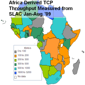
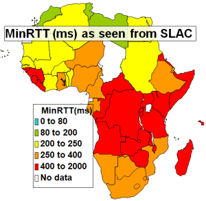
<ac:structured-macro ac:name="unmigrated-wiki-markup" ac:schema-version="1" ac:macro-id="303574e0b3c71665-a7d32de8-414c444f-87058d3f-49ab039bce41f3784574f9a5"><ac:plain-text-body><![CDATA[ | Throughput from SLAC to Regions of the World | Derived Throughput from SLAC to Africa Jan-Aug '09 [[xlsx | ^africa-thru-aug09.xlsx]] | MinRTT from SLAC - Aug. 2009 [[xls | ^map-africa-minrtt-aug2009.xls]] | ]]></ac:plain-text-body></ac:structured-macro> |
|---|---|---|---|---|---|---|
| | |
...
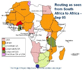
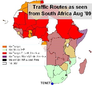
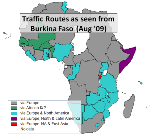
<ac:structured-macro ac:name="unmigrated-wiki-markup" ac:schema-version="1" ac:macro-id="37ebc5837d9cc36b-7eaf3c21-45e2450d-83198766-6dc41a564b2538aef8986318"><ac:plain-text-body><![CDATA[ | Routing from South Africa to African Countries (Sep '05) | Routing from South Africa to African Countries (Aug '09) [[xls | ^routing-africa-aug2009.xls]] | Routing from Burkina Faso to African Countries (Aug '09) [[xls | ^routing-africa-aug2009.xls]] | ]]></ac:plain-text-body></ac:structured-macro> |
|---|---|---|---|---|---|---|
| | |
...
One host (www.aisha.ac.zm) of the 6 monitored in Zambia improved its RTT from about 720ms to 550ms on August 20, 2009 (see below). Also at the time of writing it looks like they are still moving the link over to the terrestrial lines since the performance is very unstable (high losses) and there are big changes in RTT. It is possible the link in one direction is using a GEOS while the other is an all terrestrial link and the large dips to 400ms are when both legs are using terrestrial links. We believe the terrestrial path goes via Botswana and Namibia. The traceroute from SLAC on 9/9/09 appeared to use a satellite link in at least one direction.
...