...
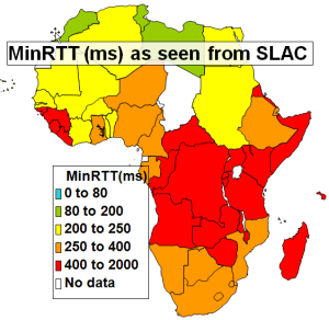
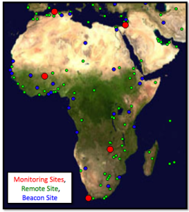
<ac:structured-macro ac:name="unmigrated-wiki-markup" ac:schema-version="1" ac:macro-id="bff7368eaee882e8-e796a552-41d84158-bbedaa97-30d8c79b719e18d95574b6a7"><ac:plain-text-body><![CDATA[ | MinRTT from SLAC - Aug. 2009 [[xls | ^map-africa-minrtt-aug2009.xls]] | PingER Coverage in Africa | ]]></ac:plain-text-body></ac:structured-macro> |
|---|---|---|---|---|
| |
...
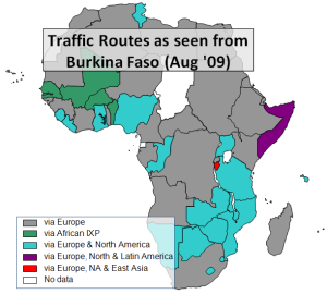
<ac:structured-macro ac:name="unmigrated-wiki-markup" ac:schema-version="1" ac:macro-id="c3ffdd2092fa183d-b33361a0-4f8e40e2-9946baa1-ecee51dfebb44586ee81b2f4"><ac:plain-text-body><![CDATA[ | NRENs in Africa | Routing from South Africa to African Countries (Sep '05) | Routing from Burkina Faso to African Countries (Aug '09) [[xls | ^routing-africa.xlsx]] | ]]></ac:plain-text-body></ac:structured-macro> |
|---|---|---|---|---|---|
| | |

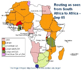
It can be seen that NRENs are being created and that in September 2008 . In September 2005 most traffic from South Africa to the rest of Africa took costly international links, only Botswana and Zimbabwe had direct routes. More details on the routes to African countries from several measurement points around the world measured in Spring 2009 can be seen in a spreadsheet of African routing and inferences.In September 2005 it can be seen that South Africa had direct connections to only Botswana and Zimbabwe. Connections to other Africanm countries all went via European or North American countries or both.
Connections from Burkina Faso in August 2009 were direct to Senegal, Mali, and Benin. Most other countries in grey are reached by intercontintal connections via Europe, followed by many taht in teal that go via Europe and N. America. Somalia is reached via Europe, N. and S. America, and . Burundi is reached via Europe, N. America and E. Asia.
...