| |
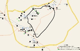
Map of PERN's connectivity to Universities in the Islamabad region. Legend for the map | Map of Islamabad area with rough guesses at locations of the PoPs. F=FJWU (chaklala 3), B= NUST, C=AIOU, D=NDC, E=QAU. The distances are: FJWU-NUST=20km, NUST-AIOU=9.3km, AIOU-QAU=17km, QAU-FJWU=30km. It is assumed the fibres roughly follow the roads. |


We calculated the lat/long of Islamabad nodes (from http://itouchmap.com/latlong.html) and calculated the distance using formula
(courtesy of http://www.meridianworlddata.com/Distance-Calculation.asp):unmigrated-wiki-markup
_d=_6378.7 * arccos\[sin(lat1/57.2958) * sin(lat2/57.2958) + cos(lat1/57.2958) * cos(lat2/57.2958) * cos(lon2/57.2958 \ -lon1/57.2958)\]_
and the Round Trip Distance RTD = 2 * d.
Using the RTD and the minimum Round Trip Time (min_RTT) we can derive alpha from
Wiki Markup
|
Plot of alpha between Universities in the Islamabad region. We use the log of alpha to enable easy visualization of the wide range of alphas found. the x-axis shows the monitoring host followed by > followed by the remote host, followed by an equal sign (=) and the great circle distance between the hosts. Spreadsheet . |

...