|
|
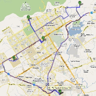
Map of PERN's connectivity to Universities in the Islamabad region. |
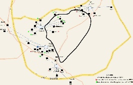
Map of Islamabad area with rough guesses at locations of the PoPs. F=FJWU (chaklala 3), B= NUST, C=AIOU, D=NDC, E=QAU. The distances are: FJWU-NUST=20km, NUST-AIOU=9.3km, AIOU-QAU=17km, QAU-FJWU=30km. It is assumed the fibres roughly follow the roads. |
We calculated the lat/long of Islamabad nodes (from http://itouchmap.com/latlong.html) and calculated the distance using formula
(courtesy of http://www.meridianworlddata.com/Distance-Calculation.asp):
d=_6378.7 * arccos[sin(lat1/57.2958) * sin(lat2/57.2958) + cos(lat1/57.2958) * cos(lat2/57.2958) * cos(lon2/57.2958 -lon1/57.2958)]
and the Round Trip Distance RTD = 2 * d.
Using the RTD and the minimum Round Trip Time (min_RTT) we can derive alpha from
RTD[km] = alpha * min_rtt [msec] * 100 km/msec
|
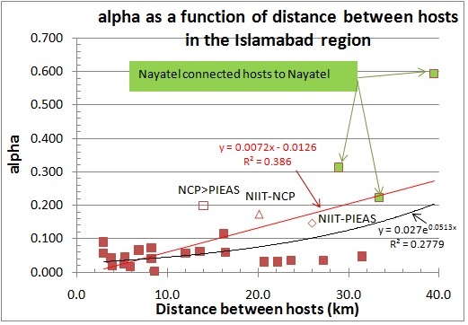
Plot of alpha between Universities in the Islamabad region. We use the log of alpha to enable easy visualization of the wide range of alphas found. the x-axis shows the monitoring host followed by > followed by the remote host, followed by an equal sign (=) and the great circle distance between the hosts. Spreadsheet . |

The connections to Nayatel have the highest values of alpha. This is for the SEECS, COMSATS and NCP hosts. Presumably they are connected to PERN via Nayatel and hence have very direct connections to Nayatel. This is confirmed by looking at the traceroutes from these three sites where it is seen that the first hops are via Nayatel. The other pair with an alpha above 0.3 is NCP and PIEAS which are connected to the same router at the QAU PoP at the Quaid-e-Azam university.
There is a weak (R 2 ~ 0.33) positive linear correlation between alpha and distance. This is seen below.
|
|
Alpha versus distance between host pairs. The red line is a linear trendline between with the parameters given in red. |
|
If one ignores the three values of alpha associated with the Nayatel host connected hosts ... (so what?)