...
The minimum RTTs measured from SLAC to African countries in August 2009 are seen in the map on the right
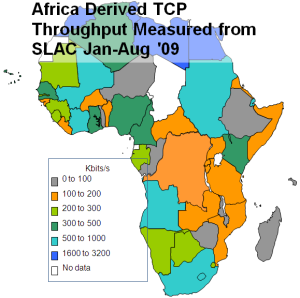
<ac:structured-macro ac:name="unmigrated-wiki-markup" ac:schema-version="1" ac:macro-id="177a205c-a194-4d6a-a13c-14addddbf45d"><ac:plain-text-body><![CDATA[ | Derived Throughput from SLAC to Africa Jan-Aug '09 [ [xlsx | ^africa-thru-aug09.xlsx]] | MinRTT from SLAC - Aug. 2009 [ [xls | ^map-africa-minrtt-aug2009.xls] | ] ]]></ac:plain-text-body></ac:structured-macro> | ||
|---|---|---|---|---|---|---|---|
| |
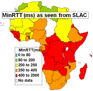
The striking number of countries in Eastern and Central Africa with minimum RTTs of >400ms is indicative that they were using GEO-Stationary (GEOS)satellite links.
...
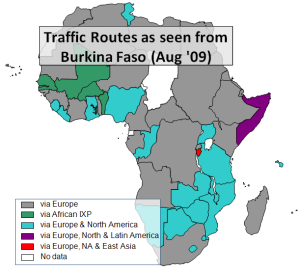
To understand the importance of NRENs and IXPs to reduce the use of intercontinental providers to get between African countries, we can look at the state of direct connections between African countries by measuring the traceroutes within Africa. Below on the left and in the middle are the routes taken from South Africa to other African countries in September 2005 and August 2009 and on the right the routes from Burkina Faso to other African countries in August 2009. In the middle map countries which were only accessible by satellite have horizontal shading lines.
...
August 2009. In the middle map countries which were only accessible by satellite have horizontal shading lines.
Routing from South Africa to African Countries (Sep '05) | Routing from South Africa to African Countries (Aug '09) [[xls | ^routing-africa-aug2009.xls] | ] Routing from Burkina Faso to African Countries (Aug '09) [[xls | ^routing-africa-aug2009.] | ] | ]]></ac:plain-text-body></ac:structured-macro> | |
|---|---|---|---|---|---|---|---|
| | |
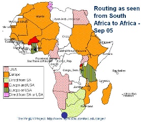
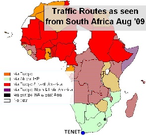
In September 2005 most traffic from South Africa to the rest of Africa took costly international links, only Botswana and Zimbabwe had direct routes. The situation has improved recently as direct routes from South Africa to Namibia and Botswana were added. More details on the routes to African countries from several measurement points around the world measured in Spring 2009 can be seen in a spreadsheet of African routing and inferences.
...