The earthquake (see http://en.wikipedia.org/wiki/2010_Chile_earthquake) struck on Saturday, 27 February at 03:34 local time (06:34 UTC),
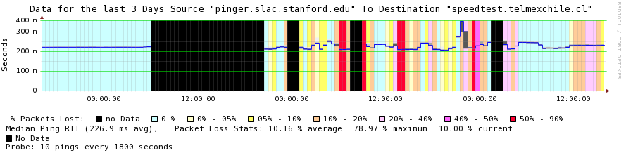
The PingER project monitors 2 hosts in Chile. Both are in Santiago about 240 miles from the epicenter. The impact of the earthquake is clearly visible. For example, below is shown a smokeping plot of RTT seen from SLAC to a node at Telmex in Santiago Chile. Telmex is an Internet service provider in Chile so it should have better connectivity than most organizations. The plot shows lack of connectivity (black), losses (colored background, see the legend below) and median RTT. The loss of connectivity following the earthquake at 6:34am UTC on February 27th is apparent. Connectivity was re-established at about 9:30pm (UTC) that evening followed by considerable instability.
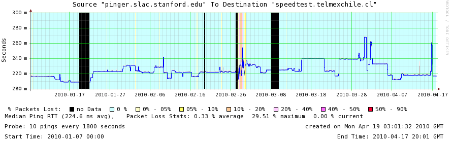
A longer term graphs is seen below:
The other Chilean node monitored (at the University of Chile also in Santiago) was unreachable from SLAC, FNAL and Japan, until March 3rd 2010.
A map of the earthquake swarm can be found at http://fromtheold.com/news/google-earth-snapshot-shows-extent-earthquake-swarm-chile-2010030216749.html. The center of the 8.8 magnitude earthquake was about 200 miles S from Santiago of the coast near Concepcion. Santiago is not shown on this map, it is about 100km ESE of Valparaiso.
Another case study of the effect of the Chilean Earthquake on the Internet as measured using BGP can be found at http://www.niclabs.cl/terremoto/en/start