Geolocating end hosts has improved dramatically in the last few years with tools such as geoiptools.com (https://www.geoiptool.net/) and the Maxmind database (https://www.maxmind.com/en/geoip2-services-and-databases?gclid=EAIaIQobChMIpqra2bry4gIViMVkCh1Z7QopEAAYAiAAEgIUyfD_BwE&rId=google). However, when it comes to router nodes, the results typically show them as being located at the owner's head office. For example, ESnet routers which are scattered over the US and also in Europe, are identified as located at the ESnet headquarters in Berkeley, California. This makes it hard to understand and visualize the router a packet takes between a source and destination.
Locating nodes
We propose to research and develop a suite of tools to use trilateration (https://www.e-education.psu.edu/natureofgeoinfo/c5_p12.html) techniques to locate hosts. In particuilar, we will focus on the needs for locating Internet routers. We plan to use Round Trip Time (RTT) measurements made by a ping-based tool from Measurement Agents (MAs) located around the world to the targets, in particular, the routers at traceroute hops. The RTTs are then converted to distance between the MA and target to input to the trilateration.
Ping Based Tool
This will typically be the traceroute.pl web-based traceroute/ping tool developed by SLAC. Others may be added should we find a set of accessible ping MAs that we can access to request pings to a target.
Locations of Measurement Agents
We will start with perfSONAR MAs and PingER MAs. A map of the initial MAs can be seen below. The red dots are MAs in the PingER project, the green dots are perfSONAR MAs.
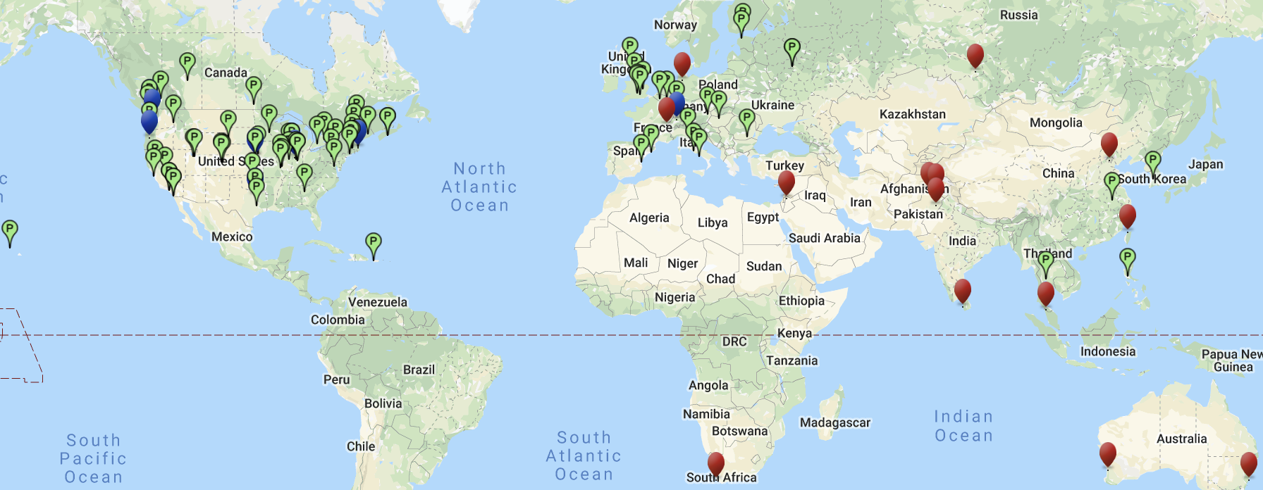
We will maintain a database of these MAs including their name, IP address, web site, physical address, and location, etc.. We will also test these MAs at regular intervals to ensure they are working and update the database of reachable active MAs accordingly. We will also contact associates, particularly in Pakistan, to add more MAs.
Populating the router location database
We will maintain a database of router locations. To populate this we will identify representative targets in regions of the world and carriers, and make regular traceroutes from the MAs to the targets and use the geolocation to locate the unknown positions of the routers at each hop. Having a database of router locations will mean the interactively locating the routes in a traceroute will be much faster and interactive. If the router location is not in the database when a user requests a visual traceroute then the result will be added to the database.
To assist in populating this database, we will also develop a tool to provide a traceroute archive. The traceroutes will be made from an MA at Stanford in the US and a second in Pakistan in Islamabad to over multiple end hosts in over 160 countries (see http://www.slac.stanford.edu/comp/net/wan-mon/viper/pinger-coverage-gmap.html for a map of the target hosts). The measurements will be made regularly (initially daily) and archived. The measurements, will be accessible via the web, together with an analysis and comparison of the traceroutes for 3 selected days (by default the most recent three days).
Traceroute visualization tool
Outcomes
A web based tool to vizualize traceroutes.
A study of the accuracy of the predictions and the impact of different numbers of MAs, their RTTs and distance to the target.
A database of the locations of Internet routers.
A publicly accessible archive of traceroutes.