| Wiki Markup |
|---|
{center}{_}By Les Cottrell,_ _[_SLAC_|http://www.slac.stanford.edu/]_
{center} |
Fibre cuts the Mediterranean The purpose of this study is to examine the effccts of fibre cuts in the Mediterranean in December 2008. The fibre cuts were reported by many sources including the BBC, Blomberg News, Al Jazeera, Orange and Wired on December 19th 2008, also see the article in Wikipedia. We decided to have a look at the impact on ping performance using the PingER data.
...
Maps of the cables and the affected countries can be found at SEAMEWE3 and SEAMEWE4. A Telegeography map of the cable routes in the Mediterranean is seen below and there is a report of progress on January 22nd:
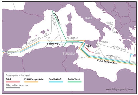 The telegeogrpahy
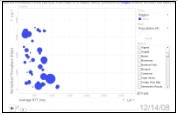
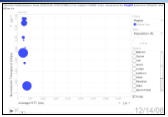
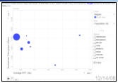
Metric Motion Charts
Probably the most dynamic way to show the effects is to use the PingER Metrics Motion Charts for the regions most badly affected, Middle East, South Asia an d Africa (Egypt and Libya). These show the variation of multiple metrics as a function of time. To assist in this we have captured the charts for 21 days starting December 14th 2008.
Losses
The measured effects on the losses seen from N. America (SLAC in California) to hosts in N. Africa (Egypt, Sudan); Middle East (Bahrein, Palestine, UAE, Oman, Jordan, Lebanon, Saudia Arabia); S. Asia (Sri Lanka, Maldives, Pakistan) are huge. As seen from PingER daily loss data measured from SLAC, comparing the losses on Friday Dec 19 with those on Mon-Thu (15-18 Dec) the losses have increased by a factor of 5 to 30 times for most of the hosts monitored in the above countries.
...