...
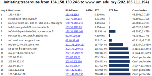
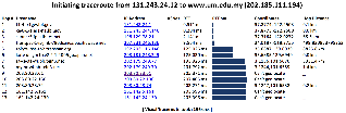
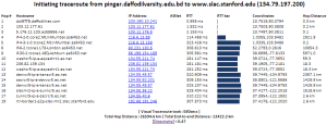
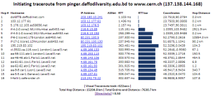
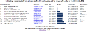
The tabular traceroute is shown together with the Autonomous System Number (ASN), if known, the router's location coordinates and distance between hops. Clicking on the IP address will take you to the TULIP geolocation utility. Clicking on the ASN will provide information on the ASN.
The From landmarks drop down list is populated from /nfs/slac/g/net/pinger/tulip/cachetr/from.txt .
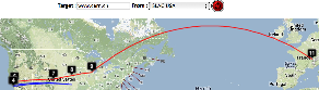
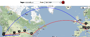
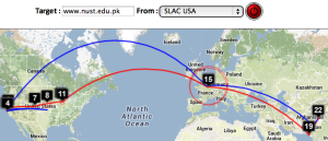
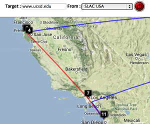
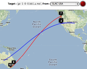
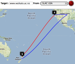
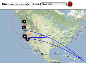
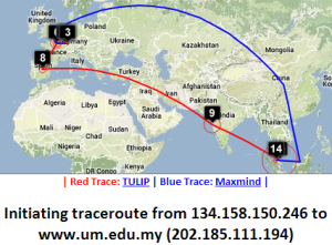
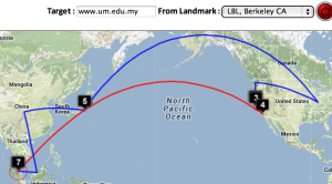
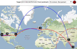
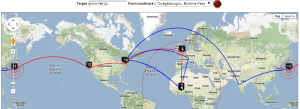
Two traceroute paths are shown on the google map. One (shown in red) is drawn using TULIP and the other (shown in blue) is drawn using MaxMind (an IP host location database). The hops are shown as appropriate numbered markers, the error in the estimated location is shown as a red circle. See the figure below:
...
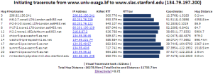
| SLAC to CERN | SLAC to ICTP Trieste | SLAC to NUST | SLAC to UCSD | SLAC to Melbourne | SLAC to Waikato New Zealand | SLAC to U Oregon |
|---|---|---|---|---|---|---|
 |  |  |  |  |  |  |
| Strasbourg to UM | LBL (Berkeley CA) to UM | ||
|---|---|---|---|
 |  | ||
 |  |
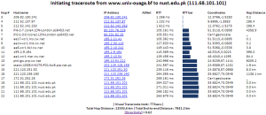
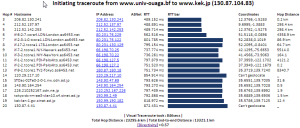
| Bangladesh to KEK, Tokyo | Bangladesh to SLAC | Bangladesh to CERN | Bangladesh to Rio de Janeiro | Burkina Faso to NUST | Burkina Faso to SLAC | Burkina Faso to KEK Tokyo |
|---|---|---|---|---|---|---|
 | 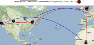 | 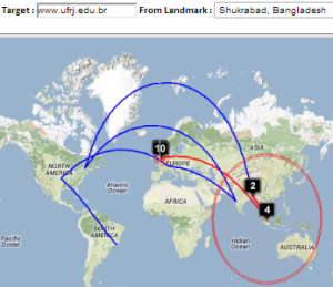 | 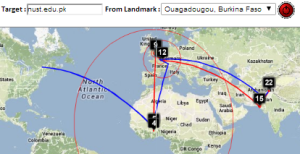 | 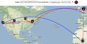 |  | |
 |  |  |  |  |  |
Other Visual Traceroutes
- CQ Traceoute, one server in St Paul, Minnesota, gives country, lat/long and distance of router from server, no map
- DNSTools, one server in Frankfurt, no lat/long, provides map
- WhatismyIPaddress, only takes IP addresses, tabular output identifying city, map shows end point only
- Montis, has 3 servers, in US (Pacific Northwest), Europe (Ireland) and Asia/Pacific (Singapore), provides map, no lat/longs or cities
- Visualware, can choose server region and a limited number of target regions, requires Java, does not support traceroutes
- VisualRoute, buy application, identifies city, no lat/longs. no map
- Free Visual, download free application, don't see a map
- VTrace multiple servers, gives lat/long plus error, provides map,city, country code
...