...
- User enters the URL with target to be geolocated.
- The TULIP visualization GUI calls the Java code to compute the answer and meanwhile sends a query string via a web service/remote routine to the Matlab server.
- The Java code computes the answer and waits for a reply from the Matlab server. The Matlab code computes an answer from data provided in the query string.Matlab Matlab server sends back a reply in the form of a dataset.
- The Java code receives the reply and merges this to other results to create a standardized XML file.
- This XML file is then read by TULIP visualization GUI to display the result on Google map. Each algorithm's result is represented in a distinct fashion.
This above is illustrated below in a diagram: 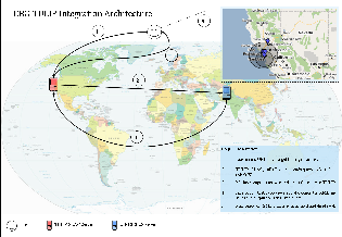
Matlab implementation
Package for Matlab implementation contains the code. To run the code:
...