...
The traceroute is as expected till Washington to Frankfurt (esnet-wash.rt1.fra.de.geant2.net). There's an increase of approx. 100ms since it crosses the Atlantic. The actual path within Germany is Frankfurt, Potsdam, Tubingen, Hamburg. Therefore Frankfurt to Potsdam is as expected. However things become strange after thatat this point. From Potsdam (zr-pot1-te0-0-0-4.x-win.dfn.de) to Tubingen (xr-tub1-vlan500.x-win.dfn.de) it takes under 3ms on average. This seems highly unlikely since Potsdam is way up north of Germany and is about 650km away from Tubingen.
...
From | To | Direction | Approx. Distance in km | Approx. Average RTT in ms | GeoIPTool | IPLocationTools | |
|---|---|---|---|---|---|---|---|
Frankfurt (esnet-wash.rt1.fra.de.geant2.net) | Potsdam (zr-pot1-te0-0-0-4.x-win.dfn.de) | Potsdam is near Berlin NE of Frankfurt | 525km | 14ms | 30km SE Bonn, 50.55N, 7.4E | 30km SE Bonn, 50.55N, 7.4E | Berlin, 52.31N, 13.24E |
Potsdam (zr-pot1-te0-0-0-4.x-win.dfn.de) | Tubingen (xr-tub1-vlan500.x-win.dfn.de) | Tubingen is SW of Potsdam | 650km | ?3ms | 30km SE Bonn, 50.55N, 7.4E | 30km SE Bonn, 50.55N, 7.4E | Jena, 50.55N, 11.34E |
Tubingen (xr-tub1-vlan500.x-win.dfn.de) | Jena Hamburg (xr-des1-te1-1.x-win.dfn.de) | Jena Hamburg is NE N of Tubingen | 445km 727km | 4ms | 30km SE Bonn, 50.55N, 7.4E | 30km SE Bonn, 50.55N, 7.4E | Jena, 50.55N, 11.34E |
Hamburg (xr-des1-te1-1.x-win.dfn.de) | Frankfurt Bremen (kr-desy.x-win.dfn.de) | Frankfurt Bremen is SW of Jena Hamburg | 300km 124km | 5ms | 30km SE Bonn, 50.55N, 7.4E | 30km SE Bonn, 50.55N, 7.4E | Berlin, 52.31N, 13.24E |
Bremen Frankfurt (kr-desy.x-win.dfn.de) | Hamburg DESY, Hamburg (rt-198-5.desy.de) | DESY, Hamburg is N NE of Frankfurt Bremen | 500km 118km | 1ms | Hamburg, 53.7333N, 9.9E | Hamburg, 53.55N, 10E | Hamburg, 53.32N, 10E |
DESY, Hamburg (rt-198-5.desy.de) | DESY (mms1.desy.de) | DESY is near Hamburg | 8km | 4ms | Hamburg, 53.55N, 10E | Hamburg, 53.55N, 10E | Hamburg, 53.32N, 10E |
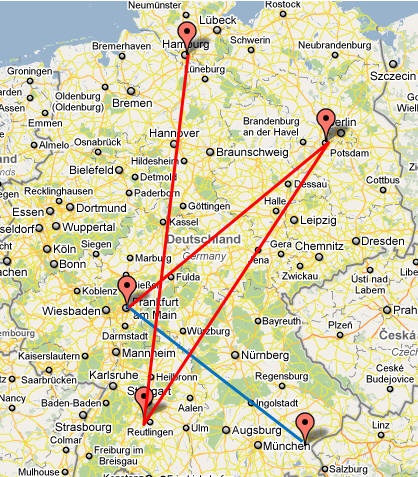
The map below shows the paths on a map. Note Garsching is located close to Munich, and Tubingen is close to Reutlingen. The route from Frankfurt to DESY is shwon shown in red, and from Frankfurt to Garsching is in blue.
This observation also points out that RTT based geolocation techniques cannot be relied upon in case of such circuitous routes.